|
|
|
|
|
|
|
|
|
OCCONEECHEE MTN. AREA |
All trails in the OCCONEECHEE AREA (Excluding Riverwalk) are contained within the Occoneechee Mountain State Park southwest of downtown Hillsborough off Orange Grove Road. Take Virginia Cades road past two small fishing lakes and park in the designated parking lot. Trails in this area are: Occoneechee Mountain Trail which goes completely around the high bluffs that make up this park; Overlook Trail which spurs off from the north side and skirts past an impressive overlook before meeting the Summit Trail to the peak (The actual peak belongs to the Orange County as is used to a communications tower and abandoned lookout - This Summit trail to the lookout towers is now closed to the public, with a large sign proclaiming it is for Authorized Personnel Only); the Chestnut Oak Trail which is brand new and cuts across the entire park east-west on the high ridgeline; and the Brown Elfin Knob Trail which explores the bluffs on the east side of the park. ( * = See Below.)
FAVORITE COMBINATION TRAILS FOR LONGER HIKES IN THIS AREA:
|
| RIVERWALK TRAIL: | NOTE: All trails marked with an asterisk (*) require access to it from another trail. Consult the maps to determine how best to reach this trail, or read the trail description for options and recommended combined trails. Mileages given here ADD to the distance required to access the trail from another. |

|
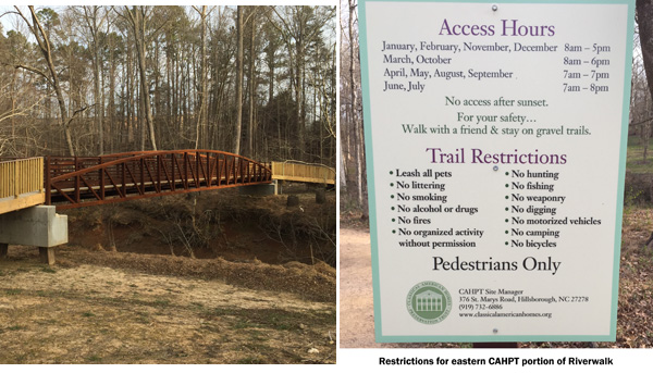
The new City of Hillsborough RIVERWALK trail is a fully paved (except for the far eastern 0.4mi section not yet completed) trail capable of handling strollers, wheelchairs, bicycles, etc., that runs along the Eno River as it passes through downtown Hillsborough. Park at either end- the Gold Park on the western end, or the River Park on the eastern end. (Note: the eastern end of this trail is depicted on the Occoneechee Speedway Trail Area map.) Eventually the Mountains-to-Sea Trail will continue from either end away from the Riverwalk Trail. For now, the MST coincides with this trail throughout its length. The trail is about 6-8 feet wide, paved in asphalt or with wood or composite bridge surfaces, and is fully capable of handling strollers, wheelchairs, bicycles or any wheeled device. There are periodic benches, trash containers and historic markers throughout the 1.3mile paved section. It crosses the Eno River in two places with sturdy steel bridges, and where it transitions to the south side of the Eno, there is a short loop trail, either fork goes to the same place. There are several side access trails that go to local neighborhoods. They have erected dog-poop stations at most access points. At the far eastern end, the trail crosses a new footbridge connecting it to the Speedway trail system across donated land from the Classic American Homes preservation Trust - owners of Ayr Mount. There are restrictions for this part of the trail as noted below
|
 BASEMAP COPYRIGHT GOOGLE MAPS; OVERLAY DATA COPYRIGHT EnoTrails.com RIGHT CLICK & "VIEW IMAGE" or "OPEN IN NEW TAB" TO DISPLAY FOR PRINTING JUST THIS MAP. |
|
|
ver. 3.1 ~ © 2011-
|